Historic 1946 Downtown Bellevue Map Beautifies Utilities Covering on Main Street

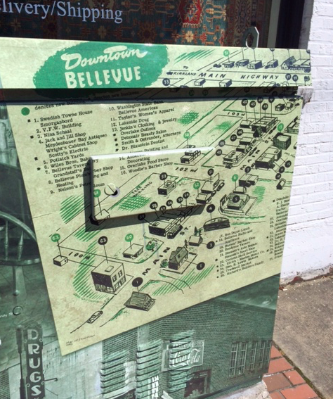
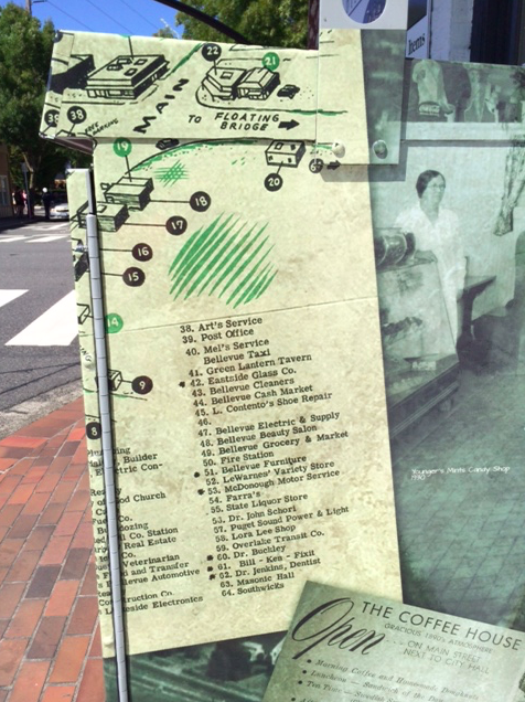
During a stroll over the weekend I came across a utilities covering at the corner of Main Street and 102nd Ave NE that has a historic 1946 map wrapping its exterior.  The map pinpoints all of the businesses in downtown Bellevue at the time, all 64 of them.

After a quick audit, it appears none of the stores are still in existence in their original location.

This is a nice way to honor the history of Bellevue in a way that everybody can experience.

We’ve reached out to the Eastside Heritage Center to find out who drove this innovative, and when it first went live but at the time of the article being posted we have not received a response.

Update: The Eastside Heritage Center provided these images to the City of Bellevue, and the City plans to wrap multiple utility boxes on Main Street. This first wrap went live in January.

Screen Shot 2014-07-29 at 2.37.08 AM

Screen Shot 2014-07-29 at 2.37.34 AM

Hot this week

4.22-Acre Mixed-Use Development Approved in Downtown Bellevue

A major mixed-use residential development in downtown Bellevue has...

Bellevue Tip Leads to Conviction in Multi-State Sex Trafficking Case

A federal sex trafficking case that began with a...

Blazing Bagels Closes All Locations, Including Bellevue

Blazing Bagels has closed all of its locations, including...

Adrian’s Restaurant & Tequila Bar in Old Bellevue Closes Abruptly

Adrian’s Restaurant & Tequila Bar has closed abruptly, according...

Salt & Straw Ice Cream Opens in Bellevue April 24 with Giveaways and Events

Salt & Straw will open a new scoop shop...

Related Articles

Popular Categories

Home Comfort Alliance - Banner 728 x 90 for HVAC